This is my codec.
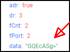
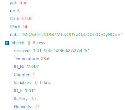
It seems the codec format has changed betver chirpstack v3 & v4…
// Decode decodes an array of bytes into an object.
// - fPort contains the LoRaWAN fPort number
// - bytes is an array of bytes, e.g. [225, 230, 255, 0]
// The function must return an object, e.g. {“temperature”: 22.5}
//function Decode( fPort, bytes )
function decodeUplink(input)
{
// Functions
function parseCoordinate( raw_value, coordinate )
{
// This function parses a coordinate payload part into
// dmm and ddd
var raw_itude = raw_value;
var temp = “”;
// Degree section
var itude_string = ( (raw_itude >> 28) & 0xF ).toString( );
raw_itude <<= 4;
itude_string += ( (raw_itude >> 28) & 0xF ).toString( );
raw_itude <<= 4;
coordinate.degrees += itude_string;
itude_string += “°”;
// Minute section
temp = ( (raw_itude >> 28) & 0xF ).toString( );
raw_itude <<= 4;
temp += ( (raw_itude >> 28) & 0xF ).toString( );
raw_itude <<= 4;
itude_string += temp;
itude_string += “.”;
coordinate.minutes += temp;
// Decimal section
temp = ( (raw_itude >> 28) & 0xF ).toString( );
raw_itude <<= 4;
temp += ( (raw_itude >> 28) & 0xF ).toString( );
raw_itude <<= 4;
itude_string += temp;
coordinate.minutes += “.”;
coordinate.minutes += temp;
return itude_string;
}
function parseLatitude( raw_latitude, coordinate )
{
var latitude = parseCoordinate( raw_latitude, coordinate );
latitude += ((raw_latitude & 0xF0) >> 4).toString( );
coordinate.minutes += ((raw_latitude & 0xF0) >> 4).toString( );
return latitude;
}
function parseLongitude( raw_longitude, coordinate )
{
var longitude = ( ((raw_longitude >> 28) & 0xF ) ).toString( );
coordinate.degrees = longitude;
longitude += parseCoordinate( raw_longitude << 4, coordinate );
return longitude;
}
function addField( field_no, payload )
{
switch( field_no )
{
// Presence of temperature information
case 0:
payload.temperature = bytes[bytes_pos_] & 0x7F;
// Temperature is negative
if( (bytes[bytes_pos_] & 0x80) > 0 )
{
payload.temperature -= 128;
}
bytes_pos_++;
break;
// Transmission triggered by the accelerometer
case 1:
payload.trigger = “accelerometer”;
break;
// Transmission triggered by pressing pushbutton 1
case 2:
payload.trigger = “pushbutton”;
break;
// Presence of GPS information
case 3:
// GPS Latitude
// An object is needed to handle and parse coordinates into ddd notation
var coordinate = {};
coordinate.degrees = “”;
coordinate.minutes = “”;
var raw_value = 0;
raw_value |= bytes[bytes_pos_++] << 24;
raw_value |= bytes[bytes_pos_++] << 16;
raw_value |= bytes[bytes_pos_++] << 8;
raw_value |= bytes[bytes_pos_++];
payload.lati_hemisphere = (raw_value & 1) == 1 ? “South” : “North”;
payload.latitude_dmm = payload.lati_hemisphere.charAt( 0 ) + " ";
payload.latitude_dmm += parseLatitude( raw_value, coordinate );
payload.latitude = ( parseFloat( coordinate.degrees ) + parseFloat( coordinate.minutes ) / 60 ) * ( (raw_value & 1) == 1 ? -1.0 : 1.0);
// GPS Longitude
coordinate.degrees = “”;
coordinate.minutes = “”;
raw_value = 0;
raw_value |= bytes[bytes_pos_++] << 24;
raw_value |= bytes[bytes_pos_++] << 16;
raw_value |= bytes[bytes_pos_++] << 8;
raw_value |= bytes[bytes_pos_++];
payload.long_hemisphere = (raw_value & 1) == 1 ? “West” : “East”;
payload.longitude_dmm = payload.long_hemisphere.charAt( 0 ) + " ";
payload.longitude_dmm += parseLongitude( raw_value, coordinate );
payload.longitude = ( parseFloat( coordinate.degrees ) + parseFloat( coordinate.minutes ) / 60 ) * ( (raw_value & 1) == 1 ? -1.0 : 1.0);
// GPS Quality
raw_value = bytes[bytes_pos_++];
switch( (raw_value & 0xF0) >> 4 )
{
case 1:
payload.gps_quality = “Good”;
break;
case 2:
payload.gps_quality = “Average”;
break;
case 3:
payload.gps_quality = “Poor”;
break;
default:
payload.gps_quality = (raw_value >> 4) & 0xF;
break;
}
payload.hdop = (raw_value >> 4) & 0xF;
// Number of satellites
payload.sats = raw_value & 0xF;
break;
// Presence of Uplink frame counter
case 4:
payload.ul_counter = bytes[bytes_pos_++];
break;
// Presence of Downlink frame counter
case 5:
payload.dl_counter = bytes[bytes_pos_++];
break;
// Presence of battery level information
case 6:
payload.battery_level = bytes[bytes_pos_++] << 8;
payload.battery_level |= bytes[bytes_pos_++];
break;
// Presence of RSSI and SNR information
case 7:
// RSSI
payload.rssi_dl = bytes[bytes_pos_++];
payload.rssi_dl *= -1;
// SNR
payload.snr_dl = bytes[bytes_pos_] & 0x7F;
if( (bytes[bytes_pos_] & 0x80) > 0 )
{
payload.snr_dl -= 128;
}
bytes_pos_++;
break;
default:
// Do nothing
break;
}
}
// Declaration & initialization
var status_ = bytes[0];
var bytes_len_ = bytes.length;
var bytes_pos_ = 1;
var i = 0;
var payload = {};
// Get raw payload
var temp_hex_str = “”
payload.payload = “”;
for( var j = 0; j < bytes_len_; j++ )
{
temp_hex_str = bytes[j].toString( 16 ).toUpperCase( );
if( temp_hex_str.length == 1 )
{
temp_hex_str = "0" + temp_hex_str;
}
payload.payload += temp_hex_str;
}
// Get payload values
do
{
// Check status, whether a field is set
if( (status_ & 0x80) > 0 )
{
addField( i, payload );
}
i++;
}
while( ((status_ <<= 1) & 0xFF) > 0 );
return payload;
}